
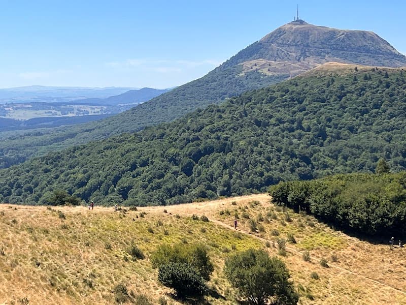
The GR441 goes round the Chaîne des Puys in a 118 km loop, waymarked white and red, to be walked in 6 days starting from Volvic. It links the cones of the north (Nugère, Chopine, Gouttes), Puy de Dôme by the Chemin des Chèvres, the foot of the twins Vache and Lassolas, the cheire d'Aydat, Servières and Orcival, then the return via Mazaye and Puy de Côme. No high mountains, but days of 6 to 7 hours. We give you the stage-by-stage breakdown, car-free access from Clermont, the bivouac rules and the period we prefer: September-October.
The GR441 in brief
The tour of the Chaîne des Puys is a loop GR, entirely in the Puy-de-Dôme, in the heart of the Parc naturel régional des Volcans d'Auvergne. You start and finish in the same place, with no shuttle to organise. Since 2018, the line of volcanoes of the Chaîne des Puys, the Limagne fault and the inverted relief of the Montagne de la Serre have been inscribed on the UNESCO World Heritage list.
The figures to keep in mind:
- Distance: 118 km for the full loop.
- Duration: 6 days.
- Short version: 86 km in 4 days, a loop starting from Saint-Ours.
- High point: Puy de Dôme, 1,465 m.
- Waymarking: white and red. The Saint-Ours to Laschamps segment is not waymarked: load the GPS track.
- Topoguide: “Volcans et lacs d'Auvergne, GR 4”, ref. 304, 9th edition of May 2026, €18.40. It also covers the GR 4 and the GR 30.
The level: no technical sections, but wooden stairs on the puys, cheires (the chaotic lava flows) and stages of 20 to 27 km. If you have already walked two days in a row with a pack, you are ready.
To place each volcano before you set off, we have a complete guide to the volcanoes of Auvergne. And if you are weighing it against the other big loop in the département, the GR30 and its tour of the lakes is longer, higher and wilder.
Which way round, and where to start
Two starting points make sense. Volvic if you come by train: the station is the terminus of the TER (regional train) from Clermont-Ferrand, at 760 m altitude, 3.6 km and 260 m of descent before the village, and the route starts from Volvic. Saint-Ours or the Goules car park if you come by car or by the Navette des Volcans: you tackle Pariou and Puy de Dôme straight away.
The direction? We like to start from Volvic heading south, clockwise: the forested cones of the north to warm up, Puy de Dôme on the second day when you are still fresh, and the return via the west, gentler, for fifth-day legs.
The stage hamlets (Laschamps, Pessade, Mazaye) are tiny. Book before you leave, especially outside July-August: a gîte closed on Tuesday evening is something you discover too late at 18:00 with 25 km in your legs.
The stages one by one
The loop is walked in six days. Here is the breakdown we recommend, clockwise. Each day gets longer or shorter depending on the gîte you book.
| Stage | Route | Key points |
|---|---|---|
| 1 | Volvic → Saint-Ours (Lemptégy) | Volvic stone, Puy de la Nugère, first cones |
| 2 | Saint-Ours → Laschamps | Chopine and Gouttes, Pariou, Puy de Dôme |
| 3 | Laschamps → Pessade | Vache and Lassolas, cheire d'Aydat, Lac d'Aydat |
| 4 | Pessade → Mazaye | Bois de Pessade, Servières, Orcival, Chevalard stream |
| 5 | Mazaye → Saint-Ours | Puy de Côme below, return towards Saint-Ours |
| 6 | Saint-Ours → Volvic | Return via the north, Tournoël in sight |
Stage 1: from Volvic to Saint-Ours, the warm-up
Volvic is the grey stone of so many Auvergne churches, and the path then climbs towards Puy de la Nugère and the wooded cones of the north of the chain. It is the most forested part of the tour, with few shops along the way: set off with your food and at least two litres of water. You arrive on the Saint-Ours side, with the Lemptégy volcano within reach: a volcano cut open by the former quarry, 2 hours 30 for the visit.
Stage 2: from Saint-Ours to Laschamps via Puy de Dôme (20 km, 6 hrs 5 min)
The finest day of the tour, and the busiest. You begin with Puys Chopine and des Gouttes, two nested volcanoes: a needle of trachyte planted in a breached crater. Allow 1 hour of climbing and 200 m of ascent. Your dog can come, on a lead: you cross grazing areas, so close the fence gates properly behind you.
Next come Puy des Goules, with a crater as round as a bowl, and Puy de Pariou, the cone on the Volvic bottles. The oak staircase that protects the slope pulls on the calves, then the crater opens up at 1,209 m. Walking the whole rim is not allowed, nor is going down to the bottom of the crater: stay on the waymarked path.
The GR then approaches Puy de Dôme from the north, by the Chemin des Chèvres, waymarked “GR 4-441”: about 6 km from the Maison de site (the visitor centre), 1 hour 30 to 2 hours, with some stretches of steps. At the summit, at 1,465 m, the Temple of Mercury and the orientation table over the eighty volcanoes you are linking on foot. Something to drink and eat, and wind.
The descent to Laschamps is by the Chemin des Muletiers: 350 m of descent, 1.9 km to the Col de Ceyssat. One point to check before fixing your dates: works close this path from Monday 5 to Friday 16 October 2026, including the weekend of the 10th and 11th, and the Col de Ceyssat car park is inaccessible for the whole period. If your knees protest, the Panoramique des Dômes rack railway takes you back down for €15.50 one way from 1 April to 30 September, €14.40 from 1 October to 31 March. We won't judge you.
Stage 3: from Laschamps to Pessade via the cheire d'Aydat (27 km, 7 hrs)
The long stage. Laschamps, a hamlet of Saint-Genès-Champanelle sitting just below 1,000 m, has Puy de Dôme in every window. You leave it by the wooded puys of Mercœur and Pelat, then the landscape changes all at once: Puy de la Vache and its twin Lassolas, two red and black cones opened in a crescent, about 8,500 years old. Since 13 May 2026, a municipal order has banned climbing either puy, which are under restoration work until 2028, with successive closures depending on the phases of the works. The long-distance trail that passes at their foot remains passable, and temporary waymarking guides visitors across the site.
From their crater came the cheire d'Aydat, the flow that dammed the valley and created Lac d'Aydat, 65 hectares at 825 m, the largest natural lake in Auvergne. It's the obvious lunch stop, and the easiest place on the tour to restock. It's also where the GR441 joins the GR30, which it meets again further on at Servières: check the signs at every junction.
The afternoon climbs back up towards Pessade, a hamlet of Saulzet-le-Froid, through summer pastures and woods. In foggy weather, keep the GPS track to hand on this section.
Stage 4: from Pessade to Mazaye via Servières and Orcival (23.6 km, 6 hrs)
The Bois de Pessade offers the finest views of the line of puys, seen from the south this time. You then pass Lac de Servières, a maar at 1,202 m: swimming and fires are not allowed, a picnic on the banks is welcome. Below, Orcival and its Romanesque basilica: water, saint-nectaire cheese, a nave worth seeing even with heavy legs.
Then the path swings west. The Chevalard stream, open spaces with the chain as a panorama, hamlets of dark stone: you leave the country of cones for that of the valleys. Mazaye is the end of the world, in the good sense of the term.
Stages 5 and 6: from Mazaye to Volvic via Puy de Côme
The climb back towards Saint-Ours passes below Puy de Côme, 1,252 m, the finest double crater in the chain. Its summit has been off-limits since 2002; the GR is content to go round it through the forest, and that suits us fine: the cone reads better from below. The Boucle des Dômes, a three-stage variant from the Parc starting from Laschamps, uses the same sector if you want a preview before the full GR.
The last day closes the loop towards Volvic from the north, with the Château de Tournoël in sight.
Getting there without a car from Clermont-Ferrand
That is the GR441's great advantage over the other Auvergne loops: three options exist without a car.
- The train to Volvic. The TER leaves Clermont-Ferrand station and drops you at Volvic in 26 minutes. Six trains a day on weekdays, three on Saturday and three on Sunday.
- The P36 bus to the foot of Puy de Dôme. From the SNCF station, line B to the Europe stop, then P36 to the Gare du Panoramique des Dômes stop in Orcines. Allow 40 to 55 minutes, roughly one departure an hour on weekdays, a little tighter at weekends. The first bus leaves Europe at 07:24 on weekdays, 08:55 on Saturday and Sunday. The T2C network is free at weekends.
- The Navette des Volcans, from 17 October to 1 November 2026 for the autumn. It links the SNCF station with the Goules car park, Vulcania and Lemptégy for €1.60 a trip, free at weekends.
Where to sleep: gîtes d'étape or bivouac
A GR441 leaflet lists the “Compagnons de Route” partner accommodation, distributed at tourist offices. In our selection, two addresses on the route:
- At Laschamps, Ô Balcons des Volcans, two 4-star gîtes with Puy de Dôme in view. More for a group of friends than a solo walker.
- At Orcines, L'Otigeon, a group gîte for up to 12 people, designed for people on the move, at the foot of Puy de Dôme. For dinner, the Auberge Fontaine du Berger serves cooking with regional flavours in a vaulted room. It closes on Monday and Tuesday, as well as Wednesday evening and Sunday evening. Booking advised.
For the night before you set off or after you arrive, our guide to where to stay in Clermont-Ferrand sorts things out by district.
Bivouac rules in the Chaîne des Puys
The classified site of the Chaîne des Puys covers twelve communes, not the whole tour: around Pessade, you leave it. Checks exist: in July 2021, an operation by the prefecture recorded bivouacs in a prohibited zone and traces of fires. What is tolerated, and what is prohibited:
- Bivouacking is tolerated, with or without a tent, as part of a long-distance hike, with the landowner's agreement. Tent pitched at sunset (20:00), packed away at sunrise (08:00).
- Never on the slopes or summits of the volcanoes. Settle at the edge of a wood, not in a hay meadow or a pasture.
- No fires: campfires, barbecues and cooking fires are prohibited all year round inside the massifs and up to 200 metres from woods, forests and heathland.
- Wild camping is flatly prohibited in a classified site.
Our advice: bivouac on the nights at Pessade and Mazaye, where there is no shortage of meadows at the edge of the woods, and sleep indoors around Puy de Dôme, where everything is regulated and busy.
The right moment: September and October
We'll tell you frankly, September and October are the GR441's best window. The beeches on the slopes turn gold, and the low raking light makes the craters as readable as a scale model. Our selection of autumn hikes in Auvergne widens the subject if you have other days ahead of you.
What changes on the route when the season turns:
- The Panoramique des Dômes changes tariff on 1 October: €15.50 one way from 1 April to 30 September, €14.40 from 1 October to 31 March.
- The days shorten fast: at the end of October, a 7-hour stage started at 10:00 finishes by headtorch. And fog clings to the plateaux of Pessade and Servières: GPS track loaded, battery full.
In winter, snow can settle above 1,000 m.
In your pack: 2 litres of water (3 on the first stage), shoes with a deep tread because the scoria rolls and the wooden stairs get slippery after rain, a windproof jacket for the summit. Dogs stay on a lead across the whole site.
Frequently asked questions
The FAQ
How many days does the GR441 take?
Six days for the full loop, 118 km starting from Volvic. There is a short version, 86 km in 4 days, a loop starting from Saint-Ours. Allow extra time if you want to visit Lemptégy or Vulcania on the way.
Can you bivouac on the GR441?
Yes, within the limits of the classified site of the Chaîne des Puys: bivouacking tolerated for long-distance hikers with the landowner's agreement, tent pitched at 20:00 and packed away at 08:00, never on the slopes or summits of the puys, never a fire. Wild camping is prohibited. Plan nights in a gîte around Puy de Dôme, which is closely watched.
Is the GR441 difficult?
No, as long as you are used to days of 6 to 7 hours with a pack. No technical sections, but days that go up to 27 km, steep wooden stairs on Pariou and Puy de Dôme, and cheires where you have to watch your feet. The real trap is fog on the southern plateaux: keep a GPS track.
Can you do the GR441 without a car from Clermont-Ferrand?
Yes, and it's one of its strengths. TER train to Volvic from Clermont-Ferrand station in 26 minutes, or line B then bus P36 to the Gare du Panoramique des Dômes stop in Orcines in 40 to 55 minutes, free at weekends. From 17 October to 1 November 2026, the Navette des Volcans also serves the Goules car park and Vulcania.