
Pérignat-ès-Allier, Landscapes marked by an ancient and medieval past
Start: Pérignat-ès-Allier
Pérignat-ès-Allier, a village more than a thousand years old, welcomes you. Close to the Allier, the commune keeps traces of the Gallo-Roman and medieval periods, which you can discover today on a route through its built heritage and natural heritage.
- Distance
- 7.9 km
- Elevation gain
- +66 m
- Elevation loss
- -66 m
- Duration
- 2 h 30 min
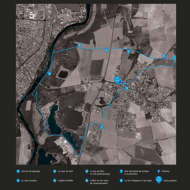
Route on the map
Base map © OpenTopoMap (CC-BY-SA): route licensed under ODbL via Données : Parc Naturel Régional Livradois-Forez · rando.parc-livradois-forez.org — sous licence ODbL.
The route in detail
Start: From the start sign, follow avenue de l'Allier to the right towards the village centre. 100 m further on, at the town hall junction, turn left, then immediately right into rue St-Laurent. Climb the lane until you come out on a road. Follow it to the left for 250 m to the roundabout.
1. Carry straight on along rue du château d'eau, through a housing estate. Then leave the road on the left at the bend and continue on a path across fields. 300 m later, at the T-junction, go left. At the next junction, bear left alongside the Combes cemetery (signs “Lecture de paysage”, reading the landscape, and “La voie romaine”, the Roman road).
2. At the D81, cross over and carry on along the Voie Romaine (take care). Continue for 900 m, ignoring all the other tracks (views of the Puy de Dôme, the Sancy and Cournon-d'Auvergne) (sign “La rase du lutin”).
3. At the D1, cross straight over (take care) and continue to the edge of a wood (signs “L'église fortifiée”, the fortified church, and “Le puy de Mur, un site préhistorique”, the puy de Mur, a prehistoric site). Carry straight on, ignoring the two paths leading off to the left, to reach the Allier. Turn left onto the path and continue for 600 m along the banks (sign “L'Allier et ses voies de communication”, the Allier and its transport links).
4. In sight of the Cournon bridge, pass under the bridge on the right and continue along the banks to enter the Écopôle du val d'Allier.
5. 250 m further on, turn left and continue on a path that makes a loop before reaching a former gravel pit on the left. 400 m further on, at the old steps of the vanished château de Bellerive, climb to the left and follow the path along the high ground. Come back down further on onto a path that you follow to the left as far as the viewpoint (to the left, access to an observatory). Continue to the right as far as the factory.
6. Then leave the road on the left and go down below to the edge of the pond, to walk round it at the foot of a high mound. 250 m further on, climb the steps on the right to a second observatory. Then turn right towards the road. Shortly before it, turn left and follow alongside it for 250 m.
7. Go under the D1 through the underpass, turn left at the wasteland, and take a path across fields on the right (sign “Une nécropole de tombes à incinération”, a necropolis of cremation graves) . At the T-junction, bear left onto a path that turns into a road as it goes through a housing estate.
8. 100 m after the bend, go down to the left then immediately right, passing the sports hall and the tennis courts. Continue until you come out at a crossroads. Climb straight ahead along rue des Charmes, then turn right into the quartier du Torrail.
9. Then continue to the left and go under the porte de la solidarité (solidarity gate) to arrive at the church. Walk round it on the right-hand side (sign “Le fort villageois et les loges”, the village fort and the loges). Then continue to the right, go past the town hall to rejoin avenue de l'Allier. Turn left to get back to the start.
In pictures
Other hikes in the area
 On foot
 On foot
 On foot